|
If you ask residents in Hamblen Township and most of Brown County if they know where Gatesville is they will say yes. But there were other settlements that came before Gatesville so how did this settlement survive? Perhaps it is because it is where roads come together. Roads that today have the names Gatesville, Salt Creek, Hoover and Sweetwater Trail. Today people travel Hoover and Salt Creek Roads to get to state highways 135 and 46 but Gatesville was decades before those highways were built.
Gatesville area is named after Bill Gates, one of the early settlers who moved here from his home in Nashville, but he was not the first to settle here. James Taggart came before him to create the Taggart settlement with two churches, a school and eventually a dance hall. Elections of township officers were held at Taggart and James Taggart was elected assessor and Justice of the Peace from time to time. So much history surrounds these small communities all across our nation. Brown County is no different. The settlers came and then various things happened, just simply because people brought new ideas and desires for things they left behind. Churches were gathering places for weddings, funerals, picnics and other social gatherings. William Hamblen's family was involved in the start of the Methodist Church that began in this area. Large meetings were held here with pastors sent out all over Indiana as Circuit Riders to bring the Methodist views to the outreaches of the southern Indiana countryside. The township was named after Job Hamblen, a Revolutionary War Veteran buried in Hamblen Cemetery just north of Gatesville. The settlers needed churches, schools, cemeteries, entertainment of some form and they also needed stores. Bill Gates as an early settler realized this and started a huckster route covering a large part of Hamblen Township. He used a wagon to sell and trade dry goods for items such as fresh fruits, vegetables, butter, chickens, and eggs. He and his wife, Alice Robinson ran the store out of their home until they built a store in 1915-18. Perhaps the longevity of a settlement rests in a grocery store. Today we know the store has had many owners, a fire, was rebuilt and Gatesville Store is still in operation. Today you can pan for gold, have lunch or rest by the creek or make arrangements to camp and you will get acquainted with Gatesville. It doesn't look much like it did in settler's days. There was a two room school in use until the 1950's; the churches are gone but the Taggart Cemetery and Hamblen Cemetery are close by, resting places for veterans from the Revolutionary, Civil and other wars. Self Guided Tour Stop # 8 Direction to Brown County State Park Stop # 9 Lets talk about the largest park in Indiana and one of the most visited state parks in Indiana, with at last count of 1.2 million visiting the natural beauty that makes this park so loved.
Lets talk about 15,252 acres of Brown County State Park being on the National Registry of Historic places. Lets talk about names. The Brown County State Park's 15,776 acres are in the county it is named after. The county was officially named in 1836, in honor of Genral Jacob Brown, a hero of the War of 1812. Richard Lieber, an Indianapolis businessman, was the first director of the Indiana Department of Conservation. During a visit to Brown County in 1910, Lieber was so impressed with the beauty of the land that he built a cabin near Nashville and suggested that a portion of the county should be set aside for a state park. Lieber eventually became known as "the father of Indiana's state parks", Lieber had the idea but it took a local Nashville resident to start the process. Lee Bright was working as an Indiana agent and knew that state funds could be used for a game preserve but not to purchase land for a state park. This was the beginning of the area becoming the vision Lee Bright had dreamed of and a game preserve was created. During November, 1924, the Indiana Department of Conservation appointed a game warden to manage the preserve.[10] The new manager was a resident of Nashville, and familiar with the area. It was also announced that much of the land would be reforested. A total of 7,680 acres of Brown County land was designated for the propagation of wildlife. Plans were made to surround the reserve with wire fencing, and game wardens patrolled the area. Deer and small game were brought in to propagate. Additional acreage was added in 1927, increasing the reserve to over 10,000 acres. During the same year, an observation tower was constructed on Weed Patch Hill, the highest point in the area. A dam was constructed in 1928 to create an artificial lake that was expected to cover 10 to 15 acres. It was planned to stock the lake with game fish then allow fishing after two or three years. The lake was completed by the spring of 1929, and plans were announced to build a second (and larger) lake. By January 1929, the preserve covered about 12,000 acres. Funds from the sale of hunting and fishing licenses were used to acquire the additional land. In 1941 the game preserve and the park were unified into one, what we know as Brown County State Park. But something major happened between those years. In the 1930s the country was trying to recover from the Great Depression. President Roosevelt created the Civil Conservation Corps and whoever wanted to work was sent to camps to work on our State Parks and other projects needing laborers. The pay was $30 a month for single young men. Company 517 sent the first young men from Fort Benjamin Harrison under the command of Captain William S. Evans, with instructions to make improvements to the Game Preserve. It was destined to be one of the biggest and best in Indiana. The CCC boys arrived at Camp S-53 in June of 1933, but they could not begin building their new homes/barracks until they cleared the weeds, man-high briars, undergrowth, and sassafras. They began their task by setting up a temporary camp in the settlement of Kelp. After a month they had to move on to Jackson County but were soon replaced. A group of 133 men arrived in July of 1933 from Company 1561., war veterans sent by train from Fort Know, Kentucky under the command of G.S. Burket. The train took them to Helmsburg. We find their opinion of their new job in a quote from one of the men when they arrived to be a "more desolate or forsaken spot could not have been found anywhere.' Fittingly, this area became known as Weed Patch Hill. Eventually these veterans cleared enough space to unload the Company's temporary home tents, bedding, food, stoves and supplies. Soon more men arrived under the company of Major Hanley. Water was the biggest problem and had to be hauled in, nearby creeks provided a place to bath until bath houses could be built along with other permanent buildings such as barracks. Water was pumped in from a nearby lake. Vocational training was offered to the workers during the winter. These men were appointed various projects that included erosion control, equipping the recreation buildings, planting 20 acres of seedlings, a new two-way highway around the loop, look-out towers built of logs, rearing pens for game birds. Pens for animals such as fox, raccoon, mink and walking trails were constructed. Raising and restocking fish in the lakes was on their list; laying pens raising pheasant for release was another. By the late 1930s the CCC men had built most all the park features, the walls, the walks, lakes, buildings, trails and roads. By 1942 the CCC had employed over 3 million men. "One of the very special things about our state park system and its rick history lies in the work of the Civilian Conservation Corps. Many roads, shelters, restrooms, gatehouses, and bridges still in use today were built by these young men during the Great Depression. We still marvel at the craftsmanship, the simple, rustic design and the way these facilities have remained to set the tone for all that has followed. " Rhonda Dunn, Archivist Brown County Historical Society Self Guided Tour Stop # 9 Where are you? You are in south central Hamblen Township, one of the very earliest areas to be settled in Brown County. It is now known as Gatesville but in earlier years the area was Taggart.
James Taggart, born 1714 in North Carolina, found his way across the Smoky Mountains to settle here in Hamblen Township. He was active in creating elections and held the first of township officers in his log home. There were no good roads coming and going to this valley and people nearby were soon defined as Ridge People to the north, Pinehurst People or Sherman People down on Salt Creek in the settlement known as Sherman. There were no luxuries and people didn't have much so they learned to stay close to home. Eventually, there was a dance hall for entertainment but there is no record of who built it or where the entertainers came from. It was written that the "good folk" shunned the dance hall and preferred the two churches in the area for social gatherings. There were two schools. We know there was a church and a school built near the Taggart Cemetery, which is nearby on Hoover Road. Taggart Cemetery located on Hoover Road, is one of the oldest cemeteries in the county on property James Taggart bought from the United States Government in 1828. The oldest tombstone dates back to 1833. Within the cemetery is a circle of stones surrounding a marker which reads: "Chimney stack marks where stood first schoolhouse and church." James Taggart was buried 1852 along with other members of his family in this cemetery named after him. There are over 133 graves in Taggart Cemetery. As in all historical cemeteries there are many unmarked graves, and some marked with rocks. The history in this historical cemetery tells so much about the settlers who came here, not the complete story but enough that encourages genealogical research. One curious marker list the children from several families that died from a communicable disease. Another is to imagine the design in the monuments that were hand carved without electricity, using hand tools and oil lamps or daylight. Enjoy your time spent in Taggart and imagine a time long ago. Self Guided Tour Stop # 7 Direction to Gatesville General Store Stop # 8 A historical building is a treasure in any community because often they are left in disrepair and deteriorate through the years. This historical house is known as the Parmerlee House built from bricks made on the property in 1837. The brick house was probably the only one at the time in the whole county. Its stately design made it unique and quite the conversation piece. Mr. James Clark Parmerlee owned a huge hide tanning business on his property across the road from his residence, buying hides from the stock yards in Chicago, St. Louis and Louisville to be processed at his tannery. Brown County was the perfect place for James and his sons to start the tannery because of its vast forest that contained Chestnut Oak. The bark from those trees were needed to tan hides. In the 1850s and '60s, up to and during the Civil War, the brick house became a hiding place for southern slaves trying to escape to the free north by way of The Underground Railroad. Validation of this happened when the current owners discovered several false walls and hiding places on the second story of the house.
And now THE STORY OF THE FARMHOUSE CAFE & TEA ROOM The present owners purchased the old house and surrounding acreage where the nursery is today. The brick house had not been lived in for many, many years. The renovation gave new life to the old brick structure. The walls of the farmhouse are three bricks thick beginning in the basement and continuing through to the full second story. Through the years families have called the Parmerlee House home and have stories of weddings and Christmases and family dinners and celebrations in the big room with the fireplace. The vision for the property, as unique as it is, out of the way and a bit of a drive off the main highway, became a business, offering a new dimension to those who live here and the visitors that come each year. In addition to the beautiful nursery of plants and herbs the owners decided to create a cafe/tea room in 2007. This was a perfect complement to the Herb Barn and quickly outgrew from a sandwich cafe into a full-service restaurant operating year round, serving delightful and delicious lunches and dinners. While diners are enjoying the ambience of the historical building and dining on everything homemade, you know by their license plates that they traveled a distance to get here. Self Guided Tour, Stop #3 Directions to the next stop, Sprunica TRULY, this blog should be about Three Notch Road and the history connected to this area of Brown County. Folk lore and settlers, many from Ohio. Churches were normally a place to gather but this road had an extra element, a stagecoach stop, and wagon traffic made Three Notch Road a busy thoroughfare. One of the stories tell how the road got its name. It was said to be the equivalent of St. Hwy. 135 widely used by people going north, even to Indianapolis and beyond. There was a sawmill or two at the top of the hill on Three Notch that led out of the valley. The horses that pulled heavy loads of logs needed a place to rest and because most roads were narrow due to the terrain, those going in opposite directions needed wider sections to pass each other. Those places were called a notch, hence that is how Three Notch Road got its name. So as people came to bring their families and make homes, they traveled this road to find a place to call home. The Taggart area was settled in 1834 before Brown County became a county on its own. Quite possibly Taggart sent word back to friends and relatives in Ohio. The first settler of record, on this ridge, was James McIlvain, who in 1841 got six different land grants on this ridge that totaled 520 acres. The ridge was suitable for farms, livestock and his home but it required clearing before that could begin. The village of Taggart was nearby, and the village of Mead was just to the north. Nashville and Williamsburg both had been settled much earlier and were growing with commerce and trade. Years of successful farming gave McIlvain the money to build his home in the 1850s, a gable-front Greek Revival two story house for his family of nine. The house served several purposes, i.e., social gatherings and a stagecoach stop where passengers could refresh, buy a meal and spend the night. Families by the names of Ford, Fordyce, Groves, Campbell, Slack and Slevin settled along Three Notch Road. They wanted a church near them and wanting to bring his faith to his new home, James donated a small portion of his land to the Trustees of Mount Zion Methodist Episcopal Church in 1873 for the purpose of a one room church, where he was a steward for 45 years. Construction of the church building had to be delayed with the start of the Civil War. The McIlvain brothers and Uriah Ford served in the war. Many families are buried in Zion Cemetery and as it grew it was made larger by land donated by Uriah Ford and John Mead. James W. McIlvain died in 1887 and is buried in the Mt. Zion Church Cemetery. Today the cemetery is maintained by the local community and volunteers with the Peaceful Valley Heritage Preservation Society's Cemetery Committee. Ninety percent of the historical monuments and tombstones have been professionally restored. The church was claimed by descendants of an originally family and has lain waste to ruin. The church bell was made in 1897 by the Shane Bell Company, Baltimore, MD, and now is on display in the Brown County Historical Society History Center for all to see. The two-story home, known as Pinehurst, is still standing just south of Zion Cemetery. It is in poor condition but is still a home. It no longer has the two story porch shown in the attached picture. It must have a tale of folklore to go with its legend. As the story goes, the first corpse to be embalmed in Brown County was in Pinehurst where curious folks gathered around to watch. Unfortunately, the body caught on fire and that was the end of the tale. The story covers over 180 years of history. You have heard the age old adage, "IF walls could talk." As we wonder about here, it should be, "If roads could talk!" Self Guided Tour Stop # 5 Directions to the next stop, Hamblen Cemetery The Story of James C. Parmerlee near Bean Blossom, Indiana by Steve Arnold (great-great-great-great-grandson) James Clark Parmerlee had already been engaged in the tanning of leather before he left Middlesex County, Connecticut before 1834 traveling with an elderly widowed mother, sister and brother-in-law west. The group first lived in Hamilton County, Ohio. Here James married Mary Burgett in the spring of 1835. The following year the couple's first son, William M. Parmerlee, was born.
According to family tradition, James and his party then settled in northern Indiana. Finding the geography there flat and forlorn, the party moved south. He and the others settled near Williamsburg, now known as Nineveh in southern Johnson County, around 1839. In this area he and his family were content. It was said that this part of Indiana's geography suited him well, as the gently rolling hills reminded him of his Connecticut birthplace. HIs sister and brother-[in-law, George and Louiza Botsford, remained in Williamsburg for the rest of their lives. In this place, James sunk vats for the tanning of leather. For a number of years, he and a few employees manufactured leather until the source of tan bark, namely from oak trees, was soon depleted. He was aware that just south of his location, Brown County, was still a large and untapped source of tan bark. It was near Bean Blossom Creek just four miles east of Bean Blossom that he chose to begin his tanning operation in Brown County. Around 1839, in the same area as James had chosen, another man, Jacob M. Neely, had already began production of leather goods. Indeed, Mr. Neely's operation was quite extensive for the time. He had sunk between 40 and 50 vats needed for the tanning of leather. When James moved into the neighborhood, around 1844, he began building another large tannery, Mr. Neely became so enraged at the prospect that another would ply the same business so close to his. According to family folklore, one early September day, Mr. Neely began walking from Bean Blossom to Nashville, in order to file a suit against James in the circuit court. On his way to the county seat, a storm suddenly formed. Out of nowhere, as if it were from some perverse divine intervention, Mr. Neely was struck by a bolt of lightning and killed instantly. Sadly, he left a widow and several children. Shortly after the episode, James' young wife became ill and died. By then, he was left to raise four children, the youngest being just three years old. It came to pass the following summer that James became betrothed to the Widow Neely. She bore James four additional children in the ensuring years. So it was that the large family shared the Parmerlee's red brick home located near his tannery. Indeed, the bricks were made on the property that the house would be built on. By 1849, there were eight tanneries in Brown County, with the Parmerlee Tannery being the most productive. After some time, James took on a partner in the business. His partner, Daniel Yandes was one of the first settlers from Indianapolis and was a highly successful businessman in his own right. So close was the partnership, that James named one of his younger sons Daniel Yandes Parmerlee. The leather tanned at the Parmerlee establishment reportedly won state, national and international prizes for its quality and had an estimated yearly income of $100,000. In the early 1870s the Parmerlee enterprise headed west. A store was purchased in Sedalia, Missouri where hides were bought and sent back to Brown County to be tanned. From Bean Blossom the tanned hides were sent back to Sedalia via the railroad. A teamster would transport the hides overland to the nearest railroad depot at Morgantown. In the early morning hours of August 10, 1872, James Parmerlee and a business associate were riding the train back home from Louisville, Kentucky when tragedy struck. The pair had been in Kentucky to register a patent. James reportedly held several patents, including a steam scouring machine. The train car carrying Parmerlee had pulled to a brief stop at the depot at Edinburgh, Indiana, when the two stepped onto the platform. The elderly Parmerlee fell under the moving train as it pulled away from the station and suffered fatal injuries. He was taken to a nearby hotel. Two doctors were summoned but to no avail. James died shortly afterward. The tannery continued in business under the leadership of his eldest son, William Parmerlee, and a younger son, James Parmerlee, Jr. Meanwhile, the store in Sedalia continued a booming business for several more years. The Bean Blossom Creek tannery continued until about 1879. In 1935, more than 50 years after the business had closed, the vats were dismantled. The Bean Blossom Bridge became listed on the National Register of Historic Places on February 10, 2022. A MODIFIED HOWE THROUGH TRUSS BRIDGE The Bean Blossom Covered Bridge is one of Indiana's most loved, painted and photographed, being featured in magazines and periodicals throughout the country. It is a very rare type bridge and one of only three still in existence. A bit of history: In June of 1880, Mathias Gilbert and 39 other concerned citizens petitioned the County Commissioners for a bridge to be built over Bean Blossom Creek to accommodate travel, teaming and transportation of mail between Nashville and Georgetown (now Bean Blossom). The petition was granted at a special meeting in July. Bids were then taken for wooden, iron and wrought iron bridges, some including masonry. The award was given to Captain Joseph Balsley, at that time a carpenter and stair builder, of Seymour, Indiana. Timber, carefully chosen, came from a farm near Nashville, and stone for abutments came from a nearby property which Captain Balsley and Albert Ludkey had found earlier. This is what made the difference in price in the bid ($1,075) and won the award. As promised the covered, wooden bridge over Bean Blossom Creek was completed by October 1, 1880. And the Captain's son, J. D. Balsley, got to paint it red! Captain Balsley passed away in 1912 and is buried in Crown Hill Cemetery, Indianapolis, Indiana. The bridge soon became part of the main road between Bean Blossom and Nashville until State Road 135 bypassed it in 1936. While frequently repaired (and even closed at times) for well over 100 years, it has somehow been carefully maintained to preserve its original form and integrity which many in the community contributed to. In 1967 the bridge was closed once again to thru traffic and in 1968 both the bridge and road were reported to be in bad condition. A campaign was started to save the bridge by Doris and Mario Panicci, who lived on a farm close by. Considerable repairs were made and approaches amended making it safe to travel again. In 1976 and 1982 it was closed for short periods for repairs. More recent was the Building Trades high school class. Under the direction of Chris Todd they renovated the bridge in 1988 using materials supplied by the Highway Department. The Bean Blossom Boosters was another group that through contributions and fund-raising activities strived to maintain it by painting, cleaning and doing minor repairs. Their members would also inspect and report any need for major work to be done to the County Commissioners. They even won a grant, which they were able to use a part of, for repairs and saved it again! Not only is it the oldest, but the only single-lane covered bridge in Indiana in its original location. So, this is where we are today. Somehow, this little old-red-bridge found off the beaten path, still captures the hearts of those who live here and those who visit as well. It may also capture yours. Written by Dorothy Babcock February 17, 2021 Sign sponsored by Faith Walk, LLC. Self Guided Tour Stop # 2 Direction to the next stop, Farm House Cafe and Tea Room. Current picture taken January 25, 2021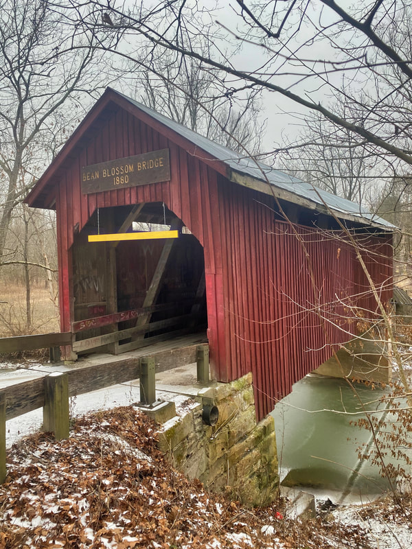 This lovely post card collection belongs to Cathy and David Martin who was kind enough to loan them to PVH for this blog. We hope you enjoy them. Stop #1 on the Self Guided Tour. Directions to the next Stop, Bean Blossom Covered Bridge The Bean Blossom Overlook is nestled in the heart of the designated "Brown County Parkway" along HWY 135N between Bean Blossom and Nashville, Indiana. This corridor was set aside to preserve the landscape's scenic beauty in 1932 by the Department of Natural Resources State Parks director, Col. Richard Lieber. In 1985, the DNR gifted approximately 150 acres of land that included the Bean Blossom overlook to the Brown County Parks & Recreation Department to ensure the property remain in local stewardship. Since that time, very little has changed, however, the maturing hardwoods continued to grow, blocking the once majestic view of the countryside. In 2017, I was approached by members of Peaceful Valley Heritage Preservation Society requesting that the Parks Department consider re-opening the view from the overlook. I was told that decades ago the spectacular view from this overlook rivaled that of any other in the state. Aside from the aesthetic benefits to the locals, the Bean Blossom overlook was, at one time, a major attraction among tourists along the parkway. I was shown late 1950's-early 1960's era photographs of families picnicking, artists with easels, painting the scenery, and others viewing the landscape will binoculars. With approval from the Park Board, and after examine several options, I reached out to a local timber buyer and arranged for a timber harvest to take place to re-open the view. This allowed the project to be completed with no cost to the BC Parks & Rec. Dept. Since the re-opining of the overlook view, we have received numerous compliments regarding the project. I have also noticed that now, each time I drive past, the overlook typically has several visitors picnicking or just enjoying the view, much the same as it did decades ago... Mark Shields, Director Brown County Parks & Recreation Postcards Supplied By: Cathy Martin Signage Sponsored By: Wolff and Wolff |
Archives
June 2023
Categories |
 RSS Feed